This chapter VII of Bibliography 7.0 contains 193 pages and >1200 titles on the deep basins of the Banda Sea region as well as the geology of the ‘Lesser Sunda Islands’, which include islands of the active East Sunda- Banda volcanic ‘inner arc’ (Flores, Sumbawa, etc.) and the non-volcanic ‘outer arc’ (Timor, Sumba, etc.). It is subdivided into five chapters, VII.1- VII.5.
VII.1. Banda Sea, East Banda Arc (incl. Tanimbar, Kai, Aru)
VII.2. Lesser Sunda- West Banda Volcanic Arc (Bali-Lombok- Flores- Wetar)
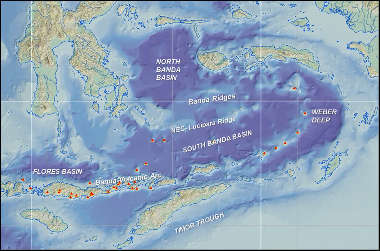
Bathymetric map showing North and South Banda Sea basins (behind the curved volcanic Inner Banda Arc), and the Weber Deep basin (between the volcanic arc and the non-volcanic Outer Banda Arc). Red triangles are active volcanoes.
VII.1. Banda Sea, East Banda Arc (incl. Tanimbar, Kai, Aru, etc.)
Sub-chapter VII.1 contains 162 references on the geology of the Banda Sea, as well as some of the non-volcanic outer arc island groups like Tanimbar, Kai and Aru.
The most prominent features in this area are the active Banda Arc, the deep Banda Sea marginal oceanic basins and the non-volcanic outer arc islands, from Sumba, Timor to the Tanimbar and Kai Islands.
Most or all of the Banda arc was built on oceanic crust, above the north-dipping Indian Ocean/ Cenotethys subduction zone. Oceanic crust has now been consumed completely from Sumba east to New Guinea.
There have been several theories on the origin of the deep Banda Sea. Verbeek (1908) noticing major extensional features along the islands surrounding the Banda Sea, (correctly) saw it as a collapsed structure. Abendanon (1919), struck by the presence of crystalline schists in much of E Indonesia, saw it as a sunken part of a large old Paleozoic continent that he named Aequinocta.
In the 1970’s it was generally recognized that the North and South Banda Seas were underlain by oceanic crust (e.g. Curray et al. 1977), but age of this crust was unknown. A theory popular in the 1980's was that the Banda Sea represented a trapped piece of Indian Ocean plate, of Early Cretaceous age (Bowin et al. 1980, Lee and McCabe 1986, Hartono 1990). This idea was mostly driven by water depths down to 5000m in the South Banda basin, which is deeper than ‘normal’ Tertiary oceanic crust.
Hamilton (1978) was the first to suggest formation of the Banda Sea by Neogene oceanic backarc spreading behind the Sunda- Banda Arc. This concept was accepted by Norvick (1979), Nishimura and Suparka (1990), Milsom (2000) and others.
The age of the Banda Sea basins seafloor is now generally viewed as Late Miocene- Early Pliocene, as documented by seafloor dredging and magnetic survey programs by French groups in the 1990’s- early 2000’s (Rehault et al. 1994, Hinschberger et al. 1998-2005, etc.). The driving force of the extension is rollback of old, N-ward subducting Indian Ocean slab (Milsom 1999, 2000, 2001, Hinschberger et al. 2003, 2005, Harris 2006, Spakman and Hall 2010, Pownall et al. 2016).
The crust below the Banda Sea seafloor is probably a mix of newly created Neogene oceanic crust, but with isolated remnants of extended older crust: (1) upper crustal blocks of continental and volcanic arc material (Banda Ridges) and (2) metamorphic core complexes of hyperextended lower crust.
The active Banda Volcanic Arc is the inner of two rows (‘arcs’) of islands surrounding the Banda Sea; the ‘outer arc’ mainly represent uplifted parts of the accretionary prism. The present cycle of arc volcanism probably started in Late Miocene time, around 10-12 Ma (Abbot & Chamalaun 1981, Scotney et al. 2005, etc), but perhaps most active since ~4 Ma. The oldest dated volcanic rocks on Wetar are ~12 Ma old (Abbott & Chamalaun,1981).
The Banda Arc is built mainly on oceanic crust, although the western Banda Arc- East Sunda Arc also have remnants of the latest Oligocene- Early Miocene ‘Old Andesites’ volcanic arc (south sides of islands of Sumbawa- Flores and islands further West). Seismic refraction work suggests Flores was probably built on 5-10 km thick oceanic crust (Curray et al. 1977, Muraoka et al. 2002).
Numerous papers have been published on geochemistry of its volcanic rocks (see table and listing below). Helium isotopes suggest contamination of Australian continental crustal material in Quaternary arc volcanics as far West as Central Flores (Hilton et al. 1992).
The size of the Banda arc volcanic islands appears to gradually diminish in an easterly direction, from the >3000m high volcanoes on Bali and Lombok to low-lying edifices in the eastern Banda Sea and front cover figure). Howevever, the volcanoes in the western part of the East Sunda- West Banda Arc are probably built on older mid-Tertiary arc crust, while volcanoes in the easternmost sector are built on >3000-4000m deep ocean floor, so the volume and vertical relief of these ‘small’ volcanic edifices is actually similar to that of much taller volcanoes in the West.
The Weber Deep or Weber Trough is anomalously deep oceanic through (down to ~7400m), located in a forearc position, between the eastern Banda Arc (where Serua- Manuk- Banda volcanoes rise from 3000m deep seafloor), and the Tanimbar- Kai - Seram outer arc islands. A new model of young hyperextension was proposed recently by Pownall et al. (2016), related to SE-ward rollback of the Australian- Indian Ocean subduction zone. This model suggests the Weber Deep may not be floored by newly formed oceanic crust, but by hyperextended lower crust metamorphic rocks or even by exhumed upper mantle ultramafic rocks.
The ‘non-volcanic outer arc’ also includes the small islands of Babar, Dai and the Tanimbar and Kai groups. These are relatively little studied. They are mainly a continuation of the forearc-accretionary system of Timor, with Triassic-Jurassic and younger sediments, folded and thrusted towards the Australian craton. On the islands closest to the Banda Sea metamorphic and ultrabasic rocks are common, a pattern similar to that seen on the Banda Sea sides of Timor and Seram.
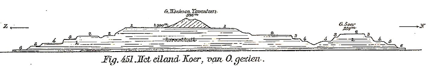
Historic W-E cross-section through Kai Besar, showing weakly folded, mainly 10° W-dipping, Eocene marly limestone, overlain by Miocene and younger reefal limestone terraces (Verbeek 1908).
Many of the islands in the East Banda area have undergone recent uplift, as demonstrated by surrounding uplifted Quaternary reef terraces (e.g. Figure of Kur Island)).
Historic S-N cross-section through Kur Island (West of Kai islands), showing six Quaternary reef terraces up to 300m elevation, and core of dipping mica schist and ?Miocene micaceous sandstones (Verbeek 1908).
Suggested Reading: Banda Sea- East Banda Arc (not a complete listing of all relevant papers)
Banda Sea region - General
Umbgrove 1948, Bowin et al. 1980, 1981, Jongsma et al. 1989, Hartono 1990, Burhanuddin et al. 1994, 1999, Rehault et al. 1994, Villeneuve et al. 1994, Honthaas et al. 1998, Milsom 2000, 2001, Hinschberger et al. 1998, 2000, 2001, 2003, 2005, Cornee et al., 1998, 2002, Pownall et al. 2016.
Banda Ridges
Silver et al. 1985, Villeneuve et al. 1994, Cornee et al.1997, 2002.
Circum Banda Sea Islands (outer arc)
Brouwer 1923, Bursch 1947; Schluter and Fritsch 1985, De Smet et al. 1989, Burollet, and Salle 1985,Van Marle and De Smet 1990, Charlton et al. 1991, Milsom et al. 1996, Honthaas et al. 1997, Callomon and Rose 2000
VII.2. East Sunda- West Banda Volcanic Arc (Lombok- Flores - Wetar)
Sub-chapter VII.2 of Bibliography 7.0 contains 218 references on the geology of the volcanic arc islands East of Java.
The islands of the East Sunda- West Banda 'inner arc' East of Bali represent a young, active volcanic arc system, mainly of latest Miocene- Recent ages. The western part of this system is underlain by crust of continental thickness, but is thinning to the East; and most or all of the volcanic islands the Banda Arc East of Flores formed on oceanic crust (Curray et al. 1977).
The southern parts of Bali, Lombok, Sumbawa and Flores have outcrops with remnants of a Late Oligocene- Early Miocene volcanic arc (Nishimura et al. 1981, Barbieri et al. 1987, Sudijono 1997, Ratman and Agustin 2005, Franchino et al. 2010, etc.). This arc probably formed on oceanic crust (e.g. Imai and Nagai 2009) and is the eastward continuation of the ‘Old Andesites’ arc of the Southern Mountains of Java and from here continues to West Sulawesi.
The geochemistry of the Banda Arc Pliocene-Quaternary volcanics shows typical intra-oceanic arc volcanic products, but the volcanics locally contain apparent contamination from a subducted continental source. This either reflects subduction of Australian-margin derived sediments, or is evidence that extended Australian continental margin crust was subducted to ~100km below the Banda Arc (Poorter et al. 1991, Elburg et al. 2004, 2005, Fichtner et al. 2010, Herrington et al. 2011, Nebel et al. 2011).
There is a gap in active volcanism in the Alor- Atauro- Wetar segment of the Banda Arc North of Timor, although large extinct volcanoes are present (Brouwer 1919, De Jong 1941; ). This lack of volcanism since ~3 Ma coincides with an absence of shallow earthquakes shallower than ~350 km in this segment.
The most likely explanation is that the subduction zone was locked here after collision of the Australian continental margin and the Banda Arc, with possible slab breakoff (Ely et al. 2011). This locking of the subduction zone probably is probably the reason for the formation of a belt of North-directed 'back-thrusting' immediately North of Alor-Wetar.
The Alor, Atauro and Wetar islands have undergone significant young uplift, with Pleistocene reef terraces up to 700- 800m (De Jong 1941, Hantoro et al. 1994, Ely et al 2006, 2011). Hantoro et al. (1994) calcaulated 580m of uplift of Alor in the last 500 kyrs.
Pliocene stratiform sulfide-barite-gold deposits now in outcrop on Wetar island (Lerokis, Kali Kuning). These are interpreted to have formed on the flanks of a submarine volcano at ~2 km depth at around 4.8 Ma, suggesting several kilometers of late uplift (Sewell and Wheatley 1994, Scotney et al. 2005).
Active belts of north-directed thrusting have been identified from reflection seismic profiles and earthquakes in the backarc regions immediately North of Flores, Alor-Wetar, Flores, etc. (Silver et al. 1983, McCaffrey and Nabelek 1984, 1986, 1987, Breen et al. 1989, Charlton 1997).
This thrusting has been explained as an early stage of subduction polarity reversal, after collision between the Banda Arc and the Australian continental margin locked the subduction zone at the Timor Trough (Silver et al. 1983). Remarkably, however, this belt of backarc thrusting may extends for ~2000km, as it can also be traced from Alor-Wetar west to North of Flores, Bali (McCaffrey and Nabelek 1987), then into southern Madura Straits and the Kendeng thrust zone of East Java, areas, where Indian Ocean subduction has not locked up yet by continent collision (e.g. Koulali et al. 2016).
Sumbawa island is part of the East Sunda- West Banda Arc system and is home to one of the largest volcanic eruptions in historic times (Tambora 1815). It is probably underlain by remnants of the Late Oligocene Early Miocene 'Old Andesites' volcanic arc and its overlying limestones (Barbieri et al. 1987, Idrus et al. 2007).
The island is also home to several large, young porphyry copper-gold deposits, at Batu Hijau (1990 discovery) and Elang (Garwin 2000, 2012 ). These deposits are part of a porphyry metallogenic belt that extends from SE Java (Tumpangpitu/ Tujuh Bukit) to Sumbawa), a sector where the Roo Rise is subducting beneath the island arc, which may or may not be related (Maryono et al. 2018).
Reported ages of mineralization include ~7- 3.7 Ma (Garwin 2002), 6-3.7 Ma (Arif and Baker 2004), 3.7 Ma (Idrus et al. 2007), between 2-2.5 Ma (Maryono et al. 2018).
Mineralization probably formed at ~5 km depth,These are now exploited in open surface mines, attesting to the large amount of young uplift.
Suggested Reading: East Sunda- Banda Arc (not a complete listing of significant papers)
General and Tectonics
Nishimura et al. 1981, Abbott and Chamalaun 1981, Silver et al. 1983, 1986, McCaffrey 1988,1989, Zen et al. 1992, Van der Werff 1996, Elburg et al. 2005, Shulgin et al. 2009, Planert et al. 2010, Luschen et al. 2011
E Sunda- Banda volcanic arc
Ehrat 1928, Kuenen 1935, Brouwer 1940-1954, De Jong 1941, Heering 1942, Hutchison 1977, 1981, Jezek and Hutchison 1978, Hendaryono 1998, Hoogewerff 1999, Hilton et al. 1989, 1992, Poorter et al. 1991, Vroon et al. 1992, 1993, 1995, 1996, 2001, Elburg et al. 2002, 2004, 2005, Ratman and Agustin 2005, Fichtner et al. 2010, Ely et al. 2011, Nebel et al. 2011
Seismicity
McCaffrey et al. 1985, McCaffrey 1989, Das 2004
Back-arc thrusting
Silver et al. 1983, 1986, McCaffrey and Nabelek 1984, 1986, 1987, Breen et al.1989, Charlton 1997
Sumbawa porphyry Cu-Au
Meldrum et al. 1994, Ali 1997, Gerteisen 1998, Arif and Baker 2004, (Batu Hijau, Elang)Garwin 2000, 2002, Idrus 2006, 2008, 2018, Aye et al. 2010, 2011, Hoschke 2012, Kepli et al. 2014, Maryono et al. 2018
Wetar massive sulphide ores
McKechnie et al. 1992, Sewell and Wheatley 1994, Scotney 2002, Scotney et al. 2005, Farmer 2011, Seran and Farmer 2012
VII.3. Sumba, Savu, Savu Sea basin
Sub-chapter VII.3 of Bibliography 7.0 contains 92 references on the geology of Sumba and nearby islands in the Banda forearc West of Timor.
Sumba island is part of a continental terrane located in the Banda forearc, between the Sumbawa- Flores sector of the Banda volcanic arc in the North, and the Java- Timor
Trench/ accretionary prism in the South. No pre- Upper Cretaceous basement is known from Sumba, but gravity and seismic refraction data suggests Sumba is underlain by >24km
thick, presumably continental crust (Chamalaun et al. 1981).
The Sumba terrane is flanked by the deep Lombok and Savu basins in the West and East, both very young and underlain by basement with oceanic crust thickness and seismic velocities (Curray et al. 1977; Karig et al.1987).
As first suggested by Hamilton (1977) Sumba is generally viewed as a micro-continental fragment that was detached from the SE Sundaland margin in Miocene time by the opening of the South Banda Sea, and moved South before the development of the present-day Banda volcanic arc (Hamilton 1979, Burollet and Salle 1982, Von der Borch et al. 1983, Audley Charles 1985, Djumhana and Rumlan 1992, Simandjuntak 1993, Wensink 1994, 1997, Van der Werff et al. 1994, Lee and Lawver 1995, Abdullah et al. 1996, 2000, Soeria-Atmadja et al. 1998, Satyana 2003, Prasetyadi et al. 2006, Satyana and Purwaningsih 2011, 2012, etc.). The most likely place of origin was the Java Sea shelf near the present Flores Basin, where it was a southern continuation of the West Sulawesi Late Cretaceous- Paleogene volcanic arc (Hamilton 1979).
However, not all authors viewed Sumba as a piece of Sundaland margin:
Audley-Charles (1975) and Chamalaun et al. tended to favor an origin from the NW Australian margin, although there are no similarities whatsoever between the stratigraphy and magmatic events of Sumba and NW Australia;
Rutherford et al. (2001) and Lytwyn et al. (2001) favored an origin of Sumba as part of the Late Cretaceous- Early Oligocene 'Great Indonesian Volcanic Arc' (which includes West Sulawesi), from which it separated at ~16 Ma and ended up in present position at ~7 Ma.
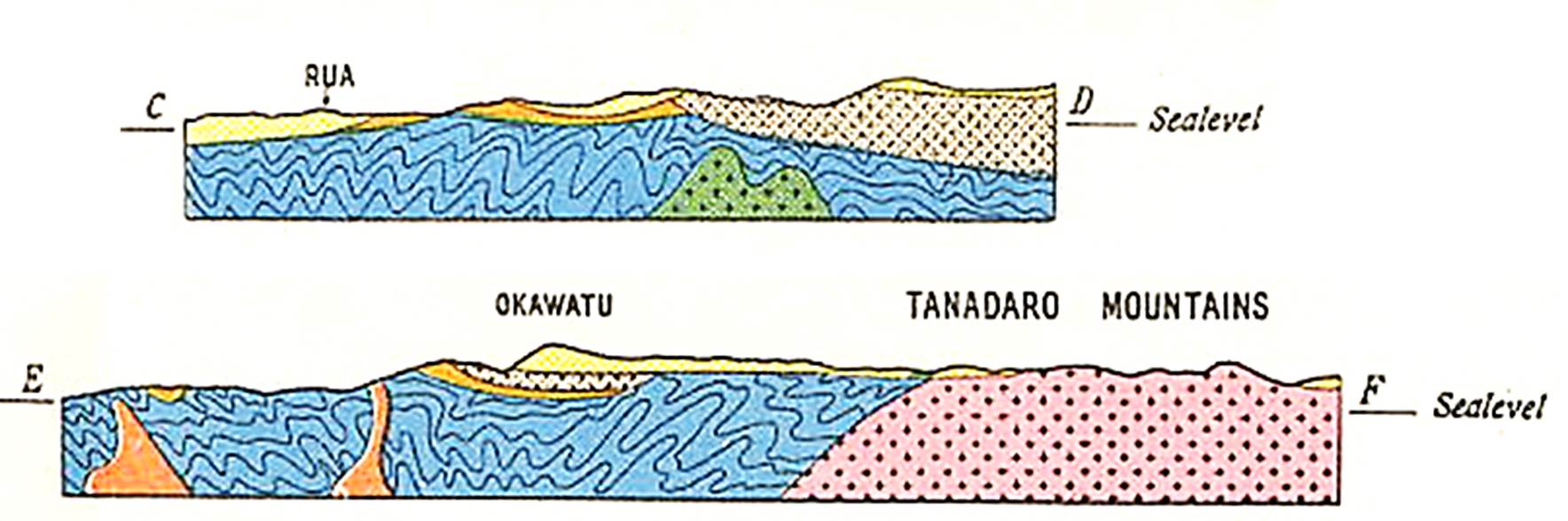
S-N cross sections of S Sumba island, showing intensely folded Cretaceous, unconformably overlain by less deformed Eocene and Miocene, and intruded by granite. (Laufer & Kraeff, 1957)
Relatively small Savu island is an uplifted part of the Savu- Roti Ridge, which is the continuation of the Outer Banda Arc accretionary prism WSW of Timor. In the Bibliography Savu references are grouped with Sumba, although there are no similarities with the geology of Sumba.
Savu is composed mainly of thrust sheets of Late Triassic- Jurassic deep marine sediments (Reed 1985, Vorkink 2004, Harris et al. 2009), presumably distal NW Australian continental margin sediments. Remarkably, Cretaceous- Early Miocene sediments appear to be missing (Harris et al. 2009).
The Savu Basin NW of Timor is a deep (>3km) and probably young basin in the forearc area North of Timor. It is underlain by by thin (12-14km) crust, possibly oceanic (Beiersdorf and Hinz, 1980, Reed 1985, Harris 2006, Fleury et al. 2009). Harris (2006) suggested it was probably part of the South Banda Sea Late Neogene extensional system.
No wells were drilled in the basin, so all all studies of sedimentation are based on uncalibrated seismic lines, extrapolated to comparable units in the onshore stratigraphies of Sumba, Savu etc..
Suggested Reading: Sumba, Savu (not a complete listing of all relevant papers)
Sumba General/ Tectonic
Caudri 1934, Van Bemmelen 1949, Laufer and Kraef 1957, Hamilton 1978, Burollet and Salle 1982, Effendi and Apandi 1982, Chamalaun et al. 1982, Von der Borch 1983, Audley-Charles 1985, Djumhana and Rumlan 1992, Simandjuntak 1993, Wensink 1991, 1994, 1997, Fortuin et al. 1991, 1992, 1994, 1997, Abdullah 1994, Abdullah et al. 1996, 2000, Soeria-Atmadja et al. 1998, Lytwyn et al. 2001, Rutherford et al. 2001, Satyana 2003, Keep et al. 2003, Fleury 2005, 2009, Satyana and Purwaningsih 2011, 2012
Sumba paleomagnetic studies
Otofuji et al. 1979, 1981, Nishimura et al. 1981, Chamalaun and Sunata 1982, Wensink et al. 1997
Savu island
Verbeek 1908, Reed 1985, Vorkink 2004, Harris et al. 2009, Roosmawati and Harris 2009
Savu Sea Basin
Reed 1985, Reed et al. 1987, Kusnida 1992, Van Weering et al. 1989, Van der Werff 1991, 1995, Fleury 2005, Fleury et al. 2009, Toothill, and Lamb 2009, Tampubolon and Saamena 2009, Rigg and Hall 2011.
VII.4. Timor, Roti, Leti, Kisar
Timor is a key area for unraveling and constraining the geodynamic history of Eastern Indonesia. Its complex geology and unique rock associations, as well as some unusually diverse Late Paleozoic- Mesozoic fossil assemblages have attracted numerous researchers since the early 1900's.
This chapter of the bibliography lists >650 papers for the combined territories of Indonesian West Timor, Timor Leste, and the adjacent smaller islands like Roti, Kisar and Leti. This does not include all papers that discuss Timor in a larger regional context.
Timor and surrounding islands are part of the Sunda-Banda 'non-volcanic outer arc', which contains both relatively undeformed parts of the Banda forearc (e.g. Sumba) and the intensely folded-thrusted collisional belt between the Banda Arc forearc and the subducting NW Australian continental margin. The fold-and-thrust belt can be traced all around the Banda Arc from the Java Trench accretionary prism in the West to Timor and futher East and NE to the islands of Babar, Tanimbar, Kai, and eventually Seram-Buru.
Timor island was first recognized as an Alpine style fold-and-thrust belt by Wanner (1913) and Molengraaff (1913, 1915). Although on an Indonesia-scale map the Timor 'foldbelt' may look small, the length of the island is ~500km, which makes it of similar size as the French and Swiss Alps combined.
Two major issues surround the tectonics of Timor, both of which have been debated for about 100 years, and both are still not settled:
how much of the Timor rock record represents the thrusted sedimentary cover of the northern Australian continental margin ('para-autochthonous') and how much represents nappes of Asian/ Banda forearc origin (‘allochthonous’)?
what was the main age of folding and thrusting on Timor: it is all young (Late Miocene- Present Banda Arc collision) or were there older deformational phases (Eocene or Oligocene)?
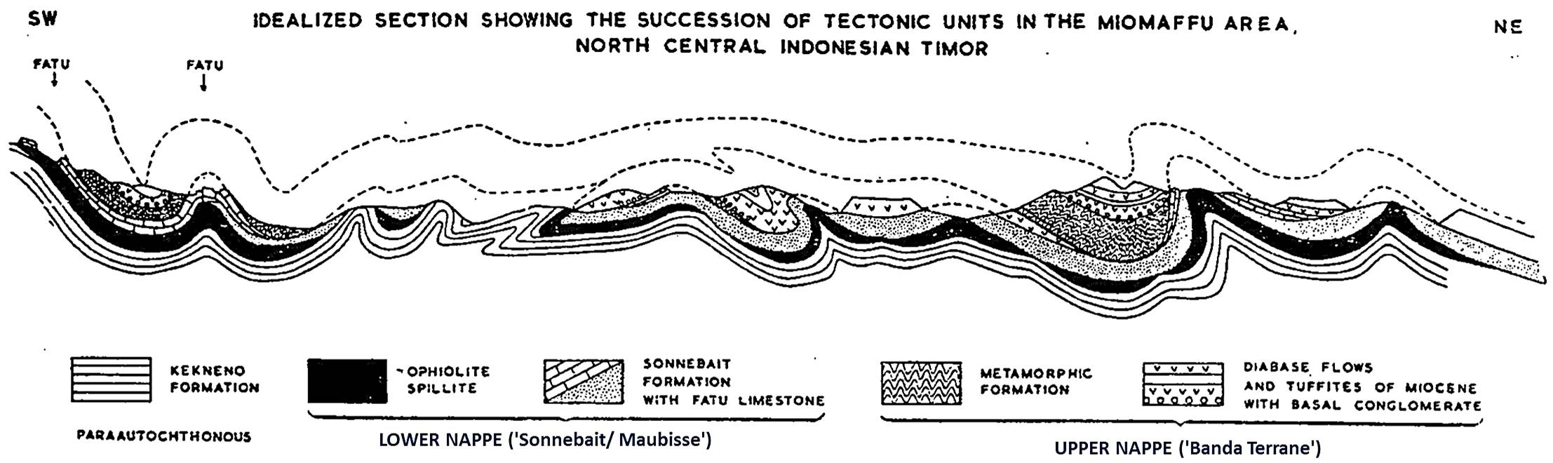
SW-NE cross-section N Central Timor from Marks (1961)
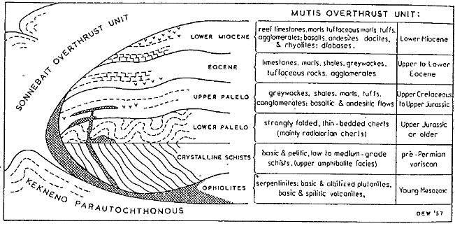
Scattered across the central zone of W Timor and E Timor are 15 complexes of the so-called 'Banda Terrane' (the ‘Schist-Palelo complex’ of Brouwer (1942) = ‘Mutis Unit’ of De Waard (1957) = Lolotoi Complex of Audley Charles (1965)). These are outcrops of metamorphic rocks (Mutis, Boi, Mollo, Lolotoi, etc.) often associated with ophiolitic rocks, stratigraphically overlain by Palelo Group Upper Cretaceous- Eocene arc volcanics and 'flysch-type' sediments. There are also Eocene shallow water carbonates with SE Asian Pellatispira forams, unconformably overlain by latest Oligocene- Early Miocene shallow water Cablac Limestone. This 'active margin' series does not tie to any rocks or events on the NW Australian margin, but it is very similar to the stratigraphy of SW Sulawesi and SE Kalimantan (Meratus). These complexes have therefore long been interpreted as 'allochtonous'.
Banda terrane stratigraphy suggests mid-Cretaceous metamorphism in a subduction zone, presumably at the SE Sundaland margin, followed by exhumation and onset of Cretaceous marine sedimentation. It formed part of the Late Cretaceous- Eocene 'Great Indonesian volcanic arc' of Harris (2006), probably at the Sundaland margin. It was affected by an Oligocene folding-uplift event during a period of carbonate deposition (also seen on Sumba and SW Sulawesi), and must have broken away from the Sundaland margin in Miocene-Pliocene time, to end up in the Banda forearc after opening of the S Banda Sea (see also Barber 1979, 1981, Earle 1979, etc.).
It may be noted that radiometric ages of the Banda Terrane metamorphics vary widely. Some are Early Cretaceous, but most of them appear to be of Eocene ages (~35-45 Ma), some even younger. Given its stratigraphic position below Late Cretaceous sediment, the post-Cretaceous ages must be too young and possibly reflect an Eocene heating event from arc volcanism. Whichever of these ages age is favored, this metamorphism is much older than the present-day Australia- Banda Arc collision and could not have taken place along the NW Shelf passive margin.
Diagrammatic stratigraphy of 'Mutis Overthrust Unit (= Banda terrane) of W Timor from Marks (1961);
Along the North coast of Timor Island (and continuing East on Kisar, Leti, Moa, Sermata, W Tanimbar, and probably all the way to Seram) are remnants of the large 'Aileu Complex' ophiolites and associated metamorphic sole rocks. The ultrabasic complex was described by a.o. Molengraaf and Brouwer (1915; Leti), Berry & Grady (1981), Berry & McDougall (1986) (Late Miocene cooling ages ~8-6 Ma), Harris (1991) and Kaneko et al. (2007).
The Aileu metamorphic complex appears to be metamorphosed 'Maubisse complex' Permian sediments and basic volcanics (Molengraaf & Brouwer 1915, Barber & Audley Charles 1977). Radiometric ages would suggest the North coast Aileu complex metamorphics/ ophiolites are younger than similar rocks of the Banda terrane of the central zone.
Another 'suspect terrane' is the Maubisse/ Sonnebait series of authors. Like the Banda terrane it is one of the higher 'nappes' and contains Permian- Cretaceous rocks and faunas that are different from the Australian NW Shelf. The Permian is composed of marls and reddish limestones (very rich in crinoids, blastoids and solitary corals of much higher diversity and more tropical aspect than nearby NW Shelf Permian), interbedded with pillow basalts, and overlain by thin, condensed, Triassic cephalopod limestones of 'Tethyan' affinity and Jurassic- Cretaceous deep sea clays and pelagic marls. It may be viewed as an oceanic seamount assemblage that formed during a Permian breakup event, then drifted in oceanic setting until Cretaceous or Eocene collision with a subduction complex.
Miocene and younger tectonics on Timor are primarily normal faulting and significant late uplift, as demonstrated by the presence of Pleistocene coral reef terraces up to 1300m elevation.
Timor has been famous for over 100 years for its rich Permian- Triassic marine macrofossils. Beautifully illustrated paleontological studies include those on ammonites (Welter 1922, Diener 1922), corals (Gerth 1921), crinoids and blastoids (Wanner 1916-1949), brachiopods (Broili 1916), molluscs (Krumbeck 1921), etc.. Unfortunately much of this material was collected from loose blocks or obtained from villagers, so stratigraphic context is often unclear.
Oil and oil and gas seeps on the island have been tied to bituminous limestones of the Triassic Aituti Formation. Due to the structural complexity of Timor island preservation of significant commercial hydrocarbon traps is unlikely and exploration is extremely challenging.
Suggested Reading: Timor (not a complete listing of all relevant papers)
Timor General, Tectonics
Wanner 1913, Brouwer 1942, De Waard 1954-1957, Grunau 1957Audley Charles 1965, 1968, 2011, Carter et al. 1976, Brunnschweiler 1978, Hamilton 1979, Barber 1981, Bowin et al. 1981,Charlton 1989, 2002, 2012, 2013, Audley Charles and Harris 1990,Sawyer et al. 1993, Reed et al. 1996, Milsom et al. 1996, 2001,Harahap 2003, Harris et al. 2000, Villeneuve et al. 1998, 2005, 2010, Harris 2006, 2011, Kaneko et al. 2007, Zobell 2007, Keep et al. 2009, Keep and Haig 2010, Haig 2012, Benincasa et al. 2012,Duffy et al. 2013, 2017, Tate 2014, Tate et al. 2014, 2015, 2017
Permian- Mesozoic stratigraphy and faunas
Many historic papers summarized in Charlton et al. (2002-Permian and 2009- Triassic), Kristan-Tollmann 1987, 1988, Bird et al. 1989, Bird and Cook 1991, Haig et al. 2007, 2010, 2014, 2017, Davydov et al. 2013, Haig and Bandini (2013).
Banda terrane/ metamorphic complexes
Molengraaff and Brouwer 1915, De Roever 1939, 1940, Tappenbeck 1940, De Waard 1954, 1957, Berry and Grady 1981,Earle 1981, 1983, 2008, Sopaheluwakan 1990,Sopaheluwakan et al. 1989,Audley Charles and Harris 1990, Harris 1991, 2006, 2011,Kaneko et al. 2007, Standley and Harris 2009
Ophiolite complexes
Harris 1989, 1992, Helmers et al. 1989, Sopaheluwakan 1990, Harris and Long 2000, Ishikawa et al. 2007, Kaneko et al. 2007.
Permian- Triassic sst provenance
Bird 1987, Bird and Cook 1991, Zobell 2007, Permana et al. 2013, Ely et al. 2014, Zimmermann and Hall 2014, 2016, Kwon et al. 2014, Spencer et al. 2016
Kolbano fold-thrust belt (Australian margin accretionary prism along South coast)
Charlton 1987, 1989, Charlton and Suharsono 1990, Harsolumakso et al. 1995, Sani et al. 1995, Keep et al. 2005
Post- orogenic Batu Putih/ Viqueque
Kenyon 1974, De Smet et al. 1990, Van Marle 1991, Haig and McCartain 2007, Roosmawati and Harris 2009, Haig 2012, Tate et al. 2014
Molengraaff and Brouwer 1915, Brouwer 1921, Kaneko et al. 2007, Kadarusman et al. 2010, Van Gorsel 2012
Savu
Verbeek 1908, Harris et al. 2009
Post-orogenic uplift
Kuenen 1933, Chappell and Veeh 1978, Tjokrosapoetro 1978, Vita-Finzi and Hidayat 1991, Roosmawati and Harris 2009
Timor paleomagnetic studies
Chamalaun 1977ab, Wensink and Hartosukohardjo 1987 1990ab, Panjaitan and Hutubessy 1997, 2004
Oil and Gas
Sawyer 1993, Cockroft et al. 2005, Charlton and Gandara 2014, Charlton et al. 2017.
VII.5. Indonesian Timor Sea, Sahul Platform
This sub-chapter contains 78 references to the geology of the Timor Trough/ Timor Sea, which is in the domain of the NW Australian continental margin, south of the Timor- Tanimbar islands. It comprises the offshore South Timor accretionary prism (the onshore part is the Kolbano fold-thrust bust of South Timor), the Timor Trench and the distal NW Australian continental margin.
Parts of the Australian continental margin are within the Indonesian Economic Zone and in the Timor Leste- Australia ZOCA joint operating zone. Significant gas fields are present in Middle- Late Jurassic and basal Cretaceous reservoir sands (Abadi, Bayu-Undan, Sunrise, Troubadour fields), similar to the 'Plover play' elsewhere in the Bonaparte Basin of the Australian NW Shelf.
The downwards flexing of the downgoing Australian plate caused widespread Late Miocene- Pliocene) normal faulting (Harrowfield et al. 2003, Keep et al. 2007).
Suggested Reading: Timor Sea (not a complete listing of all relevant papers)
General, Tectonics
Nagura et al. 2003, Seggie et al. 2003, Barber et al. 2004