Chapters I.1 and I.2 include >1530 references of textbooks and papers on the regional geology and tectonics of Indonesia and SE Asia. Chapter I.1 focuses on the regional geology of Indonesia, while chapter I.2 includes more of the regional geology of the broader SE Asia region and of the SE Asia mainland (Malaysia, Thailand, Myanmar, Vietnam, SW China, etc.). The reason for including the latter in this Indonesia-focused bibliography is that many of the geological zones of mainland SE Asia continue into parts of western Indonesia, so the tectonic history and stratigraphy of these areas are relevant to understanding parts of Sumatra, Borneo, etc..
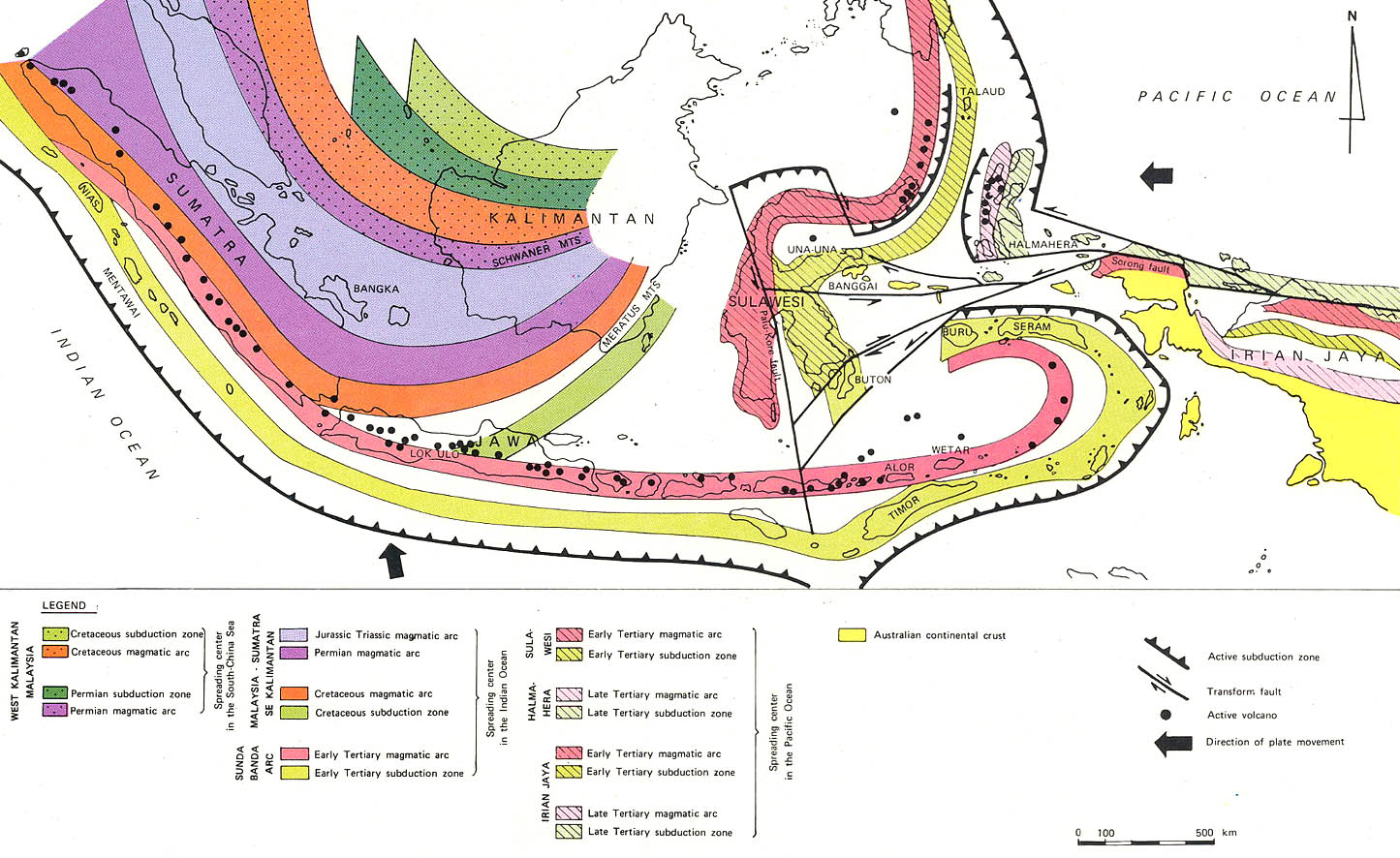
The Indonesian archipelago is an extremely complex collection of continental blocks, active and extinct volcanic arcs, old and young ocean basins and subduction complexes (commonly with ophiolites), marking the sutures where former oceans were consumed. It is now at the convergence of three major tectonic plates: Eurasia, Pacific and Australia. The island of Sulawesi contains elements of all three plates.
Multiple suture zones that separate continental blocks or continental and and arc volcanic terranes have been recognized across SE Asia. Most of these sutures represent former subduction zones along the South Eurasia and West Pacific margins, and many contain ophiolitic rocks that represent remnants of upper mantle, oceanic crust and pelagic sediment cover of closed former ocean basins (Paleo-Tethys, Meso-Tethys, Neo-Tethys/ Indian Ocean). These are accompanied by volcanic-plutonic arc systems and intensely deformed accretionary complexes.
Western Indonesia (‘Sundaland’) is a complex of Late Paleozoic- Triassic continental blocks that amalgamated by the closing of the Paleotethys Ocean suture in Late Triassic time. After a long period of relative quiescence Sundaland was affected by widespread Middle Eocene- Early Miocene rifting, creating many hydrocarbon-bearing sedimentary basins (e.g. Hutchison 1984, 1986, Hall and. Morley, 2004, Sunarjanto et al. 2008, Pubellier and Morley 2014, Rangin 2015).
The present-day configuration of Eastern Indonesia formed much later, and is still evolving. It is a collage of relatively small continental microplates derived from the Australia- New Guinea Gondwanan margin, remnants of extinct volcanic arcs, active volcanic arcs and Cenozoic oceanic marginal basins.
Numerous authors have attempted syntheses of geologic and tectonic evolution of the Indonesian Archipelago, dating back to the 1800's. Unfortunately all of the pre-1970’s tectonics models should now be viewed as largely obsolete, and mainly of historic interest, although many of these models were driven by perfectly valid geological observations.
Many newer tectonic models have been proposed since the ‘Pre-Plate tectonics era’, and new models continue to be proposed and debated today. Whilst these are all valuable exercises in integrating large amounts of geologic data, the long-term 'success rate' of any (plate-)tectonic modles of the Indonesia/ SE Asia region has not been very high, although elements of many of them continue to be accepted.
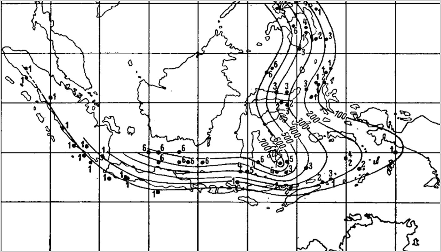
An important component in the recognition of major fault zones, and in particular subduction zones, is the distribution patterns of earthquake hypocenters. The discovery of belts of deep earthquake hypocenters in lower crust and mantle that form landward dipping zones under active continental margins is commonly attributed to Russian and Japanese seismologists Benioff and Wadati in the 1950's. However, this pattern of landward dipping planes of deep earthquake hypocenters (now known to reflect subducting slabs of oceanic lithospheric plates) was already known in the Indonesian region in the 1930's (Visser 1937, Berlage 1937, 1939).
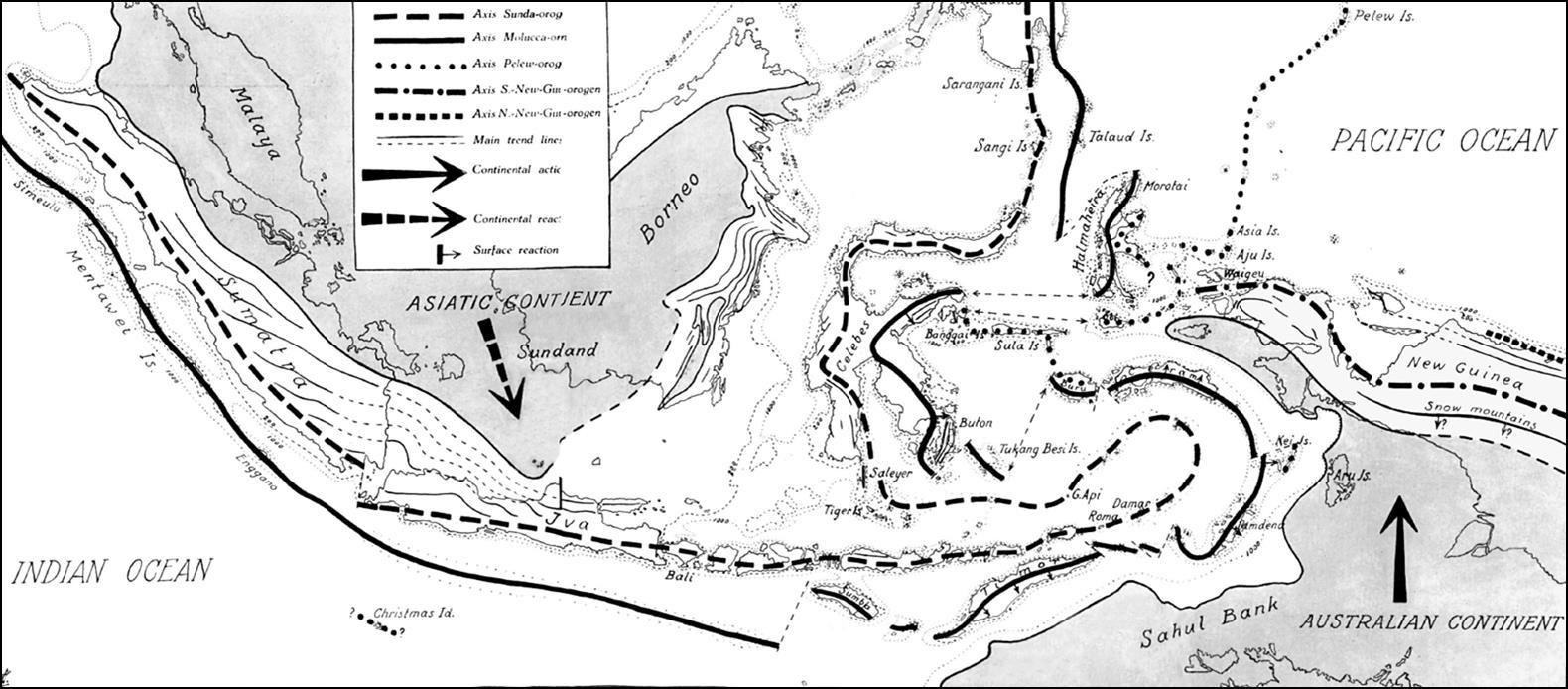
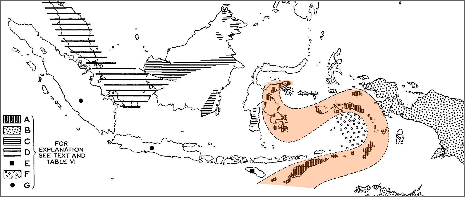
Long before the formulation of the theory of plate tectonics, the pattern of separate continental crustal blocks of Eurasian-affinity in West Indonesia and Australian-affinity blocks in East Indonesia, was recognized in the 1920's-1930's. An elegant depiction by Umbgrove (1938) shows these provinces, and where they are separated by the 'Timor- Seram- East Sulawesi geosyncline'. (zone A). This 'geosyncline' is characterized by continuous Permian- Cretaceous deep marine facies and is now understood to represent the suture zone of the Mesotethys/ Neotethys Ocean that closed around Eocene time.
| Indonesia/ SE Asia text books |
Brouwer 1925, Rutten 1927, Van Bemmelen 1949, Umbgrove 1949,Hamilton 1979, Hutchison 1989, 2007, Darman and Sidi 2000. |
| Pre-plate tectonics models |
Volz 1912, Abendanon 1914, 1915, Brouwer 1917, 1918, 1922, 1949,Van Es 1919, Smit Sibinga 1927, 1933, Umbgrove 1934, 1949, Van Bemmelen 1933, 1949, 1954,
Westerveld 1949, Klompe 1957,Carey 1958, 1975, Meyerhoff 1996. |
| Plate Tectonics syntheses: Indonesia |
Katili 1971, 1989, etc., Audley-Charles 1976, Stauffer 1974-1986, Hamilton 1979, Ridd 1980, Pigram and Panggabean 1984, Hartono and Tjokrosapoetro 1984, 1986, Barber 1985, Wood 1985, Charlton 1986,
1991,2000, 2013, 2016, Sengor et al. 1988, 2009, Gatinsky 1986, Gatinsky and. Hutchison 1986, Audley Charles and Harris 1990, Metcalfe 1988, 1996, 2002, 2009, 2011, 2013, 2017,Hutchison 1973, 1987, 19 89, 1994, 1996, 2007, 2014, Murphy 1987, 1998, 2002, Daly, Hooper et al. 1987, 1989, 1991, De Smet 1989, 1999, Rangin et al. 1990, Milsom 1992, 1993, 2000, 2001, Struckmeyer et al. 1993, Simanjuntak 1992, 1994, 2000, Prasetyo 1995, Lee and Lawver 1995, Packham 1990, 1993, 1996, Simandjuntak and Barber 1996, Hall 1996, 1998, 2002, 2009, 2012, 2017, Longley 1997, 2002, Villeneuve et al.1998, 2001, 2010, Harris 2006, Scotese 2001, R.D. Muller 2000, 2016, C.K. Morley 2002, 2012, Stampfli and Borel 2002, Pubellier et al. 2003, 2004, 2005, 2013, Satyana 2003, 2009, 2012, Gaina and Muller 2007, Golonka 2006, 2012, 2018, Spakman and Hall 2010, Clements et al. 2011, Hall and Sevastjanova 2012, Zahirovic et al. 2014, 2016, Gibbons et al. 2015. |
| GPS plate motions: SE Asia |
Chamot-Rooke et al. 1999, Rangin et al. 1999, Wilson et al. 1999, Simons et al. 1999, 2003, 2007, Becker et al. 2000, Michel et al. 2000, 2001, Pubellier et al. 2005 (DOTSEA), Calais et al. 2006, Vergnolle et al. 2007. |
| GPS plate motions: Indonesia |
Genrich et al. 1996, Walpersdorf et al. 1988, Kreemer et al. 2000, Michel et al. 2000, 2001, Bock et al. 2003, Subarya 2004, Nugroho 2005, Nugroho et al.
2009, Susilo et al. 2015, 2016, Koulali et al. 2016 |
| GPS plate motions: Sumatra |
Genrich et al. 2000, Prawirodirdjo et al.1997, 2000, McCaffrey et al. 2000, Michel et al. 2001, Simoes et al. 2004, Vigny et al. 2005. |
| GPS plate motions: Java |
Tregoning et al. 1994, Abidin et al.2009, Meilano et al. 2012, Hanifa et al. 2014. |
| Earthquakes hypocenters |
Berlage 1937, 1939, Hamilton 1974, Cardwell and Isacks 1978, 1981,Das et al. 2000. |
| Tomography velocity models |
Puspito et al. 1993, 1995) Widiyantoro and van der Hilst 1996, 1997,Hafkenscheid et al. 2001, Replumaz et al. 2004, Tregoning and Gorbatov 2004, Richards et al. 2007, Spakman and Hall 2010,Widiyantoro et al. 2011, Hall and Spakman 2015, Huang et al. 2015, Wu and Suppe 2016, 2017, Van der Meer et al. 2012, 2018. |
| Paleomagnetism Indonesia |
Haile 1976, 1978, 1981, Haile et al. 1977, Sasajima et al. 1978, 1980, 1981,Otofuji et al. 1981, Mahfi 1984, Untung et al. 1987, Schmidtke et al. 1990,
Fuller et al. 1991, 1999, Sunata and Wahyono 1991, Panjaitan and Mubroto 1993, Mubroto 1994, Richter and Fuller 1996, Wensink 1987) Van der Voo 1993, Mubroto et al. 1993,Surmont et al. 1994, Ali and Hall 1995, Hall et al. 1995, Ali et al.1996,2001, Nishimura and Suparka 1997, Mubroto and Ali 1998, Ngkoimani et al. 2005, 2006, Panjaitan 2009, Muin et al. 2017 |
| Paleobiogeography: Permian |
Asama 1976, 1984, Archbold 1983, 2000, Shen et al. 2013,Shi et al. 1995, Shi and Archbold 1998, Wang and Sugiyama 2002, Ueno 2003, 2006, Srivastava and
Agnihotri 2010. |
| Paleobiogeography: Triassic |
Ager and Sun 1988, Dagys 1993 |
| Paleobiogeography: Jurassic |
Westerrnann 1993 |
| Paleobiogeography: Cretaceous |
Uhlig 1911. |